Catoctin/Fauquier contact

Catoctin/Fauquier contact
Power washing a quarry block near Aldie, VA that preserves a soft sediment contact of the Fauquier Formation cap carbonate and pillow basalt of the Catoctin Formation.

Thursday, February 23, 2012


Proposal. Palaeoreconstruction of the ca. 2.5 Ga Batatal


reservoir: multiple geochemical research.

As Batatal Fm. is the first deep-sea section of sedimentary rocks in Minas Supergroup after Archean greenstone belt formation (Rio Das Velhas Supergroup) on the São Francisco Craton after crust reworking during Jequié Orogeny 2.7-2.5 Ga it means Batatal Fm represents the first appearance of broad (?) water masses on the São Francisco continent. Question about existence of oceans as we know it now in Archean – Palaeproterozoic time is hot debated. I propose the project about palaeoreconstruction of water masses during Batatal Fm. black shales using multiple geochemical methods: S, C, O isotopic composition, and the main redox sensitive elements (Fe, Mo, Re, U, etc). 
Age of the Batatal Fm. constraints geochronological data from lower and upper records: U-Pb 2580±7 Ma age of detrital zircon from the upper Moeda Formation quartzite and 2420±19 Ma (Pb-Pb) the Gandarela Fm. Closely age-related sections from Western Australian (Mt. Mc Shale and Mt. Sylvia Fm.) and South African (Upper Nauga and Klein Naute Fm.) cratons are well-studied and represent records formed at the same time as Batatal Fm. The similarity among these records not only composition (black shale and carbonates) but overlying BIF (banded-iron formations): Brockman in Australia, Kuruman in Africa and Cauê in Brazil. Comparison of above black shale containng formations helps us to understand spatial geochemistry of water reservoirs in time near Archean-Palaeproterozoic boundary (ca. 2580 – 2460 Ma).

Formation of Oceanic Crust and Its Impact on Thermal Structure at Mid-Ocean Ridge

Mid-ocean ridges, also known as seafloor spreading center, are locations where new oceanic crusts are being created. It is well understood that when two plates move apart, magma beneath them will ascend and cool and solidify into new crust, but things are not so clear and easy as they seem to be. A couple of geophysical and geochemical processes are involved in this intricate interaction between crust and mantle and it is also thought to vary substantially with spreading rate. For fast spreading ridges, two competing models have been proposed to explain the lower crustal accretion. In gabbro glacier model (or conveyor belt model), all the lower crust crystallize at the shallow dike-gabbro boundary and then subside into deeper crust. In sheeted sill model, lower crust is formed by sills emplaced in situ in deep crust. As for slow spreading ridges, heat supply is too slow to support a steady-state magma chamber. Whether this leads to crystallization occurring at depth or at shallow level is unknown. With the geochemical constraints from Oman ophiolite and the Hess Deep, and the seismic observations from ridges spreading at different rate, numerical models can be built to simulate the different thermal states of different models and examine the plausibilities of each model, thus address the fundamental question that how oceanic crust is formed. At the same time, most of the previous thermodynamic models of mid-ocean ridge system only account for mantle flow and thermal structure and exclude the existence of overlying crust, which definitely simplifies the model, but inevitably leaves out the possible influence of crust. If the true mechanism of crustal accretion can be identified and a crustal accretion model can be built, a more integrated mid-ocean ridge model that include both the impacts of mantle and crust can be created and will be helpful in better understanding the origin, properties, structure and behaviors of mid-ocean ridge system. So I propose to develop more realistic high-resolution 3D numerical models of mid-ocean ridges that allows for magmatic accretion of oceanic crust.
Fig1. Two models proposed for lower crustal accretion at fast spreading ridges. (A) Gabbro glacier model; (B) Sheeted sill model.

Fig2. Two models proposed for lower crustal accretion at  slow spreading ridges. 

[Proposal] Paleoclimate research of the Ediacaran Doushantuo Formation using CIA analysis.


Introduction:
In Yan et al.(2010) 's Geology paper, they established time-serious Chemical index of Alternation (CIA) curves for two shale-rich sections and  found some large-scale climatic fluctuations in the latest Ordovician in South China(Fig 1). 
Inspired from Yan et al.(2010) 's paper, I propose a similar research on paleoclimate perturbation detection of  Ediacaran strata. The Ediacaran Doushantuo Formation is often regarded as a unique window for the research of the coupled life-environment co-evolution. The Doushantuo Formation in many sections have multiple shale layers, which provides good opportunities to conduct this CIA research(Fig 2). 

Method:
Chemical index of Alternation (CIA) = Al2O3 / (Al2O3+CaO*+Na2O+K2O) × 100
The time-series CIA  trend, combined with the A-CN-K ternary diagram can provide valuable paleoclimatic information, especially the intensity degree of chemical weathering(Fig 3). 

Result expected:
(1) If the CIA trend of the Doushantuo Formation does not change so much, that means the chemical weathering during that period remains stable, or the CIA value is buffered by local silisiclastic input, which may need some stratigraphic correlations to get more information.
(2) If the CIA trend of the Doushantuo Formation does have some perturbations, this may be evidence of multiple glacial periods, or pulsed oxidation of that period. We can also combine the Sr isotope trend to get more information about the weathering condition.
(3) If this CIA method works well in Doushantuo, we can do some further stratigraphic correlation between sections in south China or worldwide(Fig4).

Potential method innovations:
The CIA analysis is often conducted on shale rocks, which represent the product of continental weathering. Can we also extend the CIA analysis into the carbonate rocks? We can acidify the carbonate rocks and get the undissolved residues, which are mainly organic matter and siliclastic components/clay minerals. These clay-rich undissolved residues can be measured by X-ray fluorescence(XRF) and get its CIA value, which represents the chemical weathering condition of the period that the carbonates precipitated.


Reference:
Yan,D. et al (2010) Large-scale climatic fluctuations in the latest Ordovician on the Yangtze block, south China. Geology http://geology.gsapubs.org/content/38/7/599.short

Fig1Large-scale climatic fluctuations in the latest Ordovician in South China. 

Fig2 Shale rocks in Doushantuo Fm, Jinlongwan section.

Fig3 The A-CN-K ternary diagram can provide valuable paleoclimatic information, especially the intensity degree of chemical weathering.
Fig4. Potential shale-rich sections for CIA stratigraphic correlation.


Examination of Fecal Indicator Bacteria in the NE Branch of the Anacostia River

The Anacostia River is a crucial stream ecosystem in Maryland and Washington D.C. and is a tributary to the Potomac River which flows into the Chesapeake Bay. However, it is also an extremely degraded ecosystem due primarily to the urbanization of the watershed. One of the major problems affecting all portions of the Anacostia River is the presence of fecal indicator bacteria, including fecal coliforms and E. coli. The tidal portion the Anacostia has high levels of bacteria due mostly to combined sewer systems (sanitary and storm water running through one pipe) in D.C. that overflow into the stream during rain events. The Maryland portion of the stream does not have combined sewers but it still has high values of fecal indicator bacteria. I propose to examine the fecal indicator bacteria loads in the North East Branch of the Anacostia River and its tributaries in order to determine the sources. The first step in doing this would be to sample for baseline conditions in the stream systems. This would involve sampling during extended periods of dry weather to determine if there are any bacteria already in the stream that are not coming from a storm event. After baseline sampling is concluded, event based sampling would occur for various magnitude rain events, to determine if any rain event would produce high bacteria levels. The ability to sample water coming off the land (possibly from the end of a storm water pipe) would be essential for the analysis as well. This will allow us to determine if there is something contributing to the bacteria load other than overland flow(flow coming from the terrestrial ecosystem), like a break in a sewer line. After the sampling is concluded the data would be compared with the data collected from my current thesis project on sediment and overland flow for the watershed. The goal of the project would be to characterize the bacteria patterns and flow paths for the watershed.
Figure 1. The North East Branch of the Anacostia Watershed with potential locations for sampling to occur.


Supercritical CO2 Injections to Enhance Biomethanogenesis in Shale Reservoirs

In light of growing demands for cleaner energy alternatives, exploration into novel ways of natural gas production is imperative.  Two mechanisms of natural gas generation exist within natural reservoirs: thermogenic and biogenic methanogenesis.  Investigation into the biogenic stimulation of natural gas from microbial consortiums (biomethanogenesis) represents one approach to addressing availability in shale reservoirs. 
            My proposed research initiative will focus on determining the effectiveness of using supercritical/liquid CO2 injections to enhance the biogenic production of natural gas in shale reservoirs.  The hypothesis being tested is that supercritical fluid CO2 will enhance porosity of shale reservoirs and thus provide greater access to biodegradable organic matter for microbial methanogenesis.  The major objectives would be to: (1) determine the interactions of liquid CO2 with different shale reservoirs of varying composition; (2) determine if these interactions can successfully enhance access to and release of biodegradable organic compounds within the rock; (3) identify the types of organic compounds that are subsequently degraded by anaerobic microbial populations; and (4) determine whether the CO2-extracted compounds have a solely stimulatory effect, or to some degree inhibit the rate and yield of microbial methanogenesis over time. 

Microtomography of Partially Molten Harzburgite: Investigating the Role of Orthopyroxene Content on Permeability

Melting of the mantle is one of the most influential geological processes on Earth.
It is responsible for the generation of crust as well as the formation of volcanic arcs like
the Cascades. In spite of its importance, the percolation of melt remains poorly
understood, especially for low melt fractions. Numerical models and laboratory
experiments suggest that there are two primary factors that influence how melt is
transported in the mantle. These are (1) the amount of melt present and (2) the
composition of the mantle, specifically orthopyroxene (Opx) content. Opx is a major
constituent of the mantle. A recent study by Zhu et al. (2011) uses a new imaging
technology called synchrotron x-ray tomography (SXT) to investigate the role of melt
fraction on melt transport of pure olivine-melt systems. However, to date, no experiment
has been conducted that quantifies the role of Opx in the transportation of molten rock in
the mantle.

I propose a study to investigate the role of composition on the permeability of
partially molten mantle rocks. This is a multi-faceted study that will incorporate elements
of fluid mechanics, experimental petrology, and numerical modeling. Over the next two
years, I will synthesize experimental charges at mantle temperatures and pressures
(1350°C / 1.5GPa) with melt fractions varying from 1-20% and Opx content varying
from 5-40%. Following the methods of Zhu et al. (2011), I will image the charges using
SXT to obtain 3D reconstructions of the charges. I will then use the finite-volume method
to solve the Navier-Stokes fluid equation for the melt portion of the samples. The goal of
this study is to obtain an empirical relation between permeability, melt fraction, and Opx
content.

Zhu, W., Gaetani, G.A., Fusseis, F., Montési, L.G.J., De Carlo, F. (2011),
Microtomography of Partially Molten Rocks: Three-Dimensional Melt Distribution in
Mantle Peridotite, Science: 332 (6025) 88-91, [DOI:10.1126/science.1202221].

The Role of Impurities on Icy Satellites

The geologic processes occurring on icy satellites can differ greatly from those occurring on terrestrial bodies (such as earth).  The main reason for this is behavior of water-ice is fairly unique in the solar system.  Water is one of the few substances that become less dense when it changes from a liquid to a solid.  Impurities in water also have a dramatic impact on the rheological characteristics of ice as well as the freezing behavior of water.    As water freezes it commonly rejects impurities and can create pockets of brine within an ice mass or it can cause a weakening of the ice because of rejection “pores”.  Most icy satellites are not composed of pure water and ice, however most models are created assuming pure water and ice.
Modeling the freezing of an impurity-rich body of water in an ice shell can provide a better understanding of the many processes occurring on icy satellites. Multiple models would need to be created using different impurities in order to systematically explore the impact of possible impurities in ice.   These impurities include clathrates, ammonia and salts.  This could lead to better constraints on the composition of individual icy satellites.  Freezing impure-water containing may also play an important role in cryovolcanism on icy satellites.   

Geyser on Enceladus.  Courtesy JPL/NASA


Bio-Geomechanics of Carbon Mineralization

      One of the major obstacles in carbon mineralization research has been the failure to observe magnesite precipitation in Mg2+- and CO32--saturated solutions at realistic reservoir temperatures.  The limited evidence available suggests a kinetic barrier to the nucleation of magnesite crystals in magnesite-saturated solutions.  In nature, the precipitation of carbonate minerals is often biologically mediated; however, no laboratory studies have been done expressly to study the possible role of microbiota in the catalysis of carbon mineralization reactions, and in general no note is made of the presence of absence of microbiota in chemical kinetic and geomechanical tests preformed in laboratories.  In the interest of exploration of all possible relevant parameters to the carbon sequestration effort, as well as realistic characterization of natural geological settings, the investigation of the role of biologically mediated carbonate precipitation in mafic and ultramafic reservoirs is warranted.
      Carbon sequestration is a nascent field.  Progress in research depends on the individual efforts of many labs working in a variety of fields as well as their collaboration.  While the fields of chemistry, geomechanics and engineering in regards to carbon sequestration have begun to work with one another, the field of biology has been left behind.  It is a living world we seek to heal.  The integration of biology into the carbon sequestration research effort could prove to be crucial.

Biostratigraphy and Paleobiogeography of Postosuchus

Rauisuchids (Postosuchus and a few closely related species) are currently considered to be the closest relatives (sister group) to crocodylomorphs (a group which includes modern day crocodiles). However, the evolutionary history of these animals is still poorly understood, making it difficult to determine the origins of Crocodylomorpha. Rauisuchids are also important because, as some of the top land predators of the Triassic, they were in direct competition with early carnivorous dinosaurs and thus are significant in understanding the early evolution of dinosaurs. In order to increase our knowledge of rauisuchids and the evolutionary origins of both dinosaurs and crocodylomorphs, I propose a multi-phase study of the rauisuchid genus Postosuchus, focusing on biostratigraphy and biogeography. Postosuchus lived in the Late Triassic of North America and currently includes two species - P. kirkpatricki and P. alisonae - from Texas and North Carolina, respectively. The first step of this study would be to conduct field collections in under-sampled parts of the Newark Supergroup, Dockum Group, and Chinle Formation, as an attempt to increase the number of specimens of Postosuchus. The second step would be detailed descriptions of all specimens referred to Postosuchus with evidence based species diagnosis. A significant amount of material from the Chinle Formation has been tentatively identified as Postosuchus, but has not been intensively described or studied. It is possible that there may be a third species represented in the Chinle Formation. After all specimens are accurately identified, the data can then be assessed for stratigraphic (temporal) and geographic (spatial) pasterns. We can then start to answer some of the many questions about rauisuchids. Were rauisuchids affected by the Manicouagan impact like aetosaurs and phytosaurs? Did Postosuchus originate in Texas and spread from there? Is Polonosuchus a European descendant of Postosuchus?

A geographic reconstruction of the Late Triassic (220 Ma) by Ron Blakey.

Hydrocarbon Fingerprinting and its Application in Forensic Geology


Unwanted hydrocarbons are often detected in soils or groundwater before a leak is discovered. If these hydrocarbons are found, geologists are called to determine the source, impact and degree of contamination, and methods for recovery and cleanup. A useful tool for studying this is capillary column gas chromatography-mass spectrometry (GCMS). Retention time on a chromatogram can help identify key hydrocarbons, such as n-paraffins (alkanes). The shape of the n-paraffin envelope as well as the presence of other compounds such as olefins (alkenes) and additives creates a characterizing signature of hydrocarbon type. GCMS is considered to be the ‘gold standard’ for forensic analysis because it can identify whether there is an actual presence of a particular substance in a sample. Separately, each analytical method would be incomplete; the mass spectrometer normally requires a pure gas sample, and a gas chromatogram cannot differentiate between molecules with the same retention time. The applications for this method include linking or eliminating a leak with a specific source, differentiating between similar-grade products, and identifying how other organic compounds may be mistakenly identified as hydrocarbon contamination.

Example gas chromatography paraffin envelope from a hydrocarbon contamination study.


A proposal to study the genesis of Oceanic Island Basalts using Cl isotopes: Graveyard of subducted oceanic crust in the lower mantle?


Subduction of oceanic crust is a crucial part of the Earth crust-mantle mass cycling. Though being studied for decades, the fate of subducted crust remains highly debated today. How deeply down can these crustal materials travel and survive the extreme P-T conditions in the mantle? The lower mantle, which is inferred by Oceanic Island Basalt (OIB), shows evident chemical and isotopic enrichment compared with the upper mantle. These crust-like signatures have led many people to assume that the subducted oceanic crust can traverse the upper mantle and thrust deeply into the lower mantle (e.g. Weaver, 1991 and the references therein). To test this hypothesis, we now propose employing Cl isotopes to trace the subducted crustal materials.

Chlorine has two naturally occurring isotopes: 35Cl (75.8%) and 37Cl (24.2%), both of which are stable isotopes. The large relative mass difference between the two isotopes indicates obvious isotopic fractionation during geological processes. High solubility of Cl makes it highly enriched in seawater, which in turn, results in the elevated Cl abundance in seawater altered basalts and sediments on the seafloor. When the altered oceanic crust and overlying sediments subduct into the mantle, Cl is efficiently extracted and recycled into the mantle wedge, as a result of dehydration (Straub et al., 2003). During this process, the light 35Cl is preferentially lost, leaving the dehydrated oceanic crust and sediments enriched in 37Cl compared with the upper mantle. If these 37Cl-rich materials can be subducted to the lower mantle and contribute to the source of Oceanic Island Basalts, we may expect to see the Cl isotopic composition in Oceanic Island Basalts distinct from Mid-Ocean Ridge Basalts, which represent the upper mantle.


References

Straub, S.M., Layne, G.D., 2003. The systematics of chlorine, fluorine, and water in Izu arc front volcanic rocks: Implications for volatile recycling in subduction zones. Geochimica et Cosmochimica Acta 67, 41794203.

Weaver, B.L., 1991. The origin of ocean island basalt end-member compositions: trace element and isotopic constraints. Earth and Planetary Science Letters 104, 381-397.

Friday, February 10, 2012

Stokes' Setting Velocity

v_s = \frac{2}{9}\frac{\left(\rho_p - \rho_f\right)}{\mu} g\, R^2

where:
  • vs is the particles' settling velocity (m/s)
  • g is the acceleration due to gravity (m/s2),
  • ρp is the mass density of the particles (kg/m3), and
  • ρf is the mass density of the fluid (kg/m3)
  • μ is the dynamic viscosity (N s/m2),
  • R is the radius of the spherical object (in m)


Thursday, February 9, 2012

The Destructive Power of Salt…


For many, the idea that a single salt crystal forming would have the strength to topple a building is not realistic.  But if multiple crystals form within a foundation they can do just that.  Salt growth has the power to destroy cement blocks, roadways, and building walls from the inside out.  These processes have been well documented not only in scientific and historic literature but also in flat tires and expensive foundation repairs.  So how does this happen and how else could we be affected by mineral growth inside of tiny holes?
Figure 1: This is what can happen to a cement block that is left standing in 
less than 1 cm of salt water for 47 days. [Image source: G. Scherer]

This cement block is a great example of what a salt solution can do when it infiltrates pore spaces through capillary action and evaporation.  Capillary action is what happens when your towel touches the surface of water.  The whole towel may not get submerged but you can watch the water climb up the towel until either the whole towel is wet or gravity stops the process.  In this block tiny grains of salt crystals grew both from the inside and on its surface.  The mineral growth from the internal pore spaces led to all of the damage seen.  The engineers performing this experiment were determining the conditions for which crystal growth will occur within the block causing instability and ultimately failure.  As you can see they definitely achieved their goal.  It was determined that an excess of salt water alone would not allow the crystals to grow beyond simply filling the pore spaces of the material.  There must be a disjointing force to prevent the crystal from coming in direct contact with the pore space walls.  This is similar to the effect that water has when you drive through a water puddle in your car.  If the puddle is not deep your tires will stay in contact with the roads surface and you will not lose control.  On the other hand, if the water is deep it will force the tires away from the road and your day gets bad really quickly.  In the case of the mineral growth, a force must be imparted to push the crystal away from the wall instead of coming in contact with the wall, thus cracking the cement block. 
Figure 2: The results of an increasing disjoining force, from simply 
cracking to total failure.  [Image source: C. Noiriel et al.]
 
So how does this information help a geologist?
          Investigation into the engineer’s study reveals applications that might be of great interest for geologists; particularly in the field of carbon sequestration.  From a geologist’s perspective, carbon sequestration involves the capture and injection of CO2 into depleted oil and gas reservoirs.  Here is the correlation; instead of allowing a fluid (oil) to rise to the surface we are artificially forcing fluids into a confined environment.  The pore spaces in this environment are not filled with air as one might think instead they are usually filled with a complex salt water solution.  So what happens when this solution gets exposed to mixtures that are foreign to the confining pressures of such an environment?  Well that is not fully understood, but one scenario that may occur is the dehydration of the salt water resulting in crystal growth within pore spaces….  That sounds familiar.
          Simply translating the engineers work to a completely different set of conditions is not practical as there are numerous variables that do not lineup with their work.  One such variable is the confining pressure, or the pressures on a rock exerted on it by all of the surrounding rocks, and how this pressure might impact any disjoining forces within a rock.  Fortunately for us, we have the ability to simulate these pressures here at Maryland.  If crystal growth does occur to the point of cracking the pore space walls could this lead to instability within the reservoir?  With any luck we will better understand at least this part of the question.

Image Sources and Further Reading
Scherer, G.W., 2004, Stress from crystallization of salt, Cement and Concrete Research, 34(9): 1613-1624.
Noiriel, C., Renard, F., Doan, M-L., Gratier, J-P., 2010, Intense fracturing and fracture sealing induced by 
       mineral growth in porous rocks, Chemical Geology, 269(3-4): 197-209.

The Melt Redemption


Fig.1 Mid-Ocean ridges are large mountain ranges
underwater, with intense heat activities
Where is the longest and largest mountain range in the world? Himalayas? Andes? No. It is under the sea. Known as Mid-Ocean Ridge, the huge underwater mountain system extends as long as 65000 km and connects the undersea mountains from Pacific to Atlantic, forming spectacular landscape in the midst of the vast seafloor. Mountaineers in the legendary kingdom of Atlantis, if this kingdom exists, might be excited to climb these mountains, but they’d better take good care of their feet, because mid-ocean ridges could be very hot. Black smokers with temperature ranging from 60 °C to as high as 464 °C have been discovered along mid-ocean ridges by deep-sea explorations. These heat and energy released by the black smokers are believed to have given birth to the life on Earth, and are closely related to the magma movement beneath mid-ocean ridges.

Like cut pie, the Earth’s surface is broken up into several pieces called plates, which move in relation with one another. Mid-ocean ridges, or tectonically known as divergent plate boundaries, are places where two plates are moving apart. The change of temperature and pressure in this process causes the rocks beneath mid-ocean ridges to melt and erupt and then solidify, forming new crust along mid-ocean ridges, and that is the mountain range we see under the sea. The axis of a mid-ocean ridge is always believed to be the exit for the upwelling melts to erupt. However, recent observations suggest that those naughty melts (or magma) have probably already found a secret passage to escape. Throughout the global mid-ocean ridge system, mid-ocean ridges are cut by huge fractures called transform faults. Previous theories believe that these fractures, with efficient cooling, may direct melts away, but recent research showed that there is thickened crust along transform faults, which indicates active magma activity in these regions.  

Hebert and Montesi (2011) apply a 3D model of melt movement to investigate the unusual thickened crust along an oceanic transform, and suggest that the faults and cracks in transform region might create connected channels and should be responsible for the melt redemption. In 2D, melt migration at mid-ocean ridge system can be modeled by a process with two steps: (1) vertical upwelling under buoyancy; (2) lateral migration along a low-permeability lid inclined towards the ridge axis. However, in 3D, the existence of the transform will affect the melt pathway to the ridge axis and result in thickened crust. Hebert and Montesi solve a 3D model based on a thermal structure that incorporates important parameters, and emphasize the potential structural controls on melt concentration in transform faults. Their results show that the structural damage such as faults and dikes, intersects the lid on the melt pathway, redistributes ridge crust to the transform domain, and accounts well for the unusual crustal thickness at transform faults observed. Their research gives a new perspective in the study of the origin of the huge mountain range under the sea, and can be used to explain the heat distribution along mid-ocean ridges, contributing to the efforts in unveiling the mysteries of this region.

Fig.2 Sketches for melt pathway beneath a ridge and a transform respectively. The melts are guided by a lid called permeability barrier and may be extracted by some structural damages to the surface, forming thickened crust


Reference

Hebert, L. B., and L. G. J. Montési (2011), Melt extraction pathways at seg- mented oceanic ridges: Application to the East Pacific Rise at the Siqueiros transform, Geophys. Res. Lett., 38, L11306, doi:10.1029/2011GL047206.

Of Meteorites and Mulch - Events of the Late Triassic

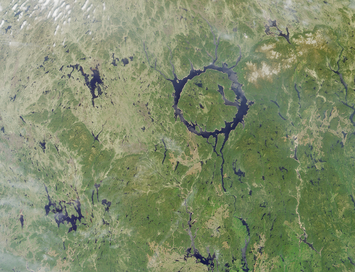
About 215 million years ago, a meteor smashed into eastern Canada, creating the Manicouagan crater, one of the largest ever discovered. What affect did this impact have on life? Meteorite impacts are often suggested as the cause of mass extinctions, the most notorious of which was responsible for ending the reign of the dinosaurs 65 million years ago. So far, this dinosaur destroying impact - the Chixulub crater on the Yucatan Peninsula - is the only crater to be directly linked to any extinction, big or small. The effects of the Manicouagan impact have yet to be found, but rocks in the southwestern United Startes are starting to change that.

Figure 1. Satellite image of the Manicouagan crater. Today, it forms a circular lake, 70 km in diameter, in northeaster Quebec, Canada. (Image by NASA)

The Chinle Formation is exposed throughout northern Arizona, southern Utah, southwestern Colorado, and northwestern New Mexico and represents river deposits from the Late Triassic. Scientists have been studying the rocks and fossils of the Chinle for over a century, especially in Petrified Forest National Park, but it was only in the last few years that the stratigraphy (the order in which rocks were deposited) was properly worked out. Once these rock layers were placed in the proper order, an interesting pattern developed. It was noticed that certain fossils only appeared in the upper part of the Chinle (younger rocks) while completely different fossils appeared in the lower part (older rocks) and that these two groups of fossils (called "faunas") were separated by a distinct, and geologically abrupt, layer. This layer, and therefore the transition between the two faunas, is represented by a thin layer (about 10 cm) of bright red, petrified "mulch". Geologists call this silcrete, because it is very hard, like concrete, and made up almost entirely of the mineral silicate. It occurs in a group of rocks called the Sonsela Member, which can be easily seen throughout the southern half of Petrified Forest.
Figure 2. The red silcrete cascades down the sides of rocky knolls as erosion wears away the underlying rock.


 Although many different fossil species are known throughout the Chinle Formation, the difference between the two faunas - named the Adamanian (below) and Revueltian (above) - is most striking in just two types of animals. Each fauna has its own species of phytosaur (large, crocodile-like animals) and its own species of aetosaur (large, armadillo-like animals), shown in figure 3. Fossils of these animals are abundant and therefore make it easy to distinguish which fauna is represented in which rocks. It is interesting to note that these animals get smaller as you pass from the Adamanian to the Revueltian. Several other animals show this pattern as well.

Figure 3. Phytosaurs (left) and aetosaurs (right) that represent the two faunas. The older (Adamanian) species are distinctly larger than their younger (Revueltian) counterparts. (Adapted from an image by Jeff Martz)
Figure 4. Chinle stratigraphy with ages, showing the
mulch layer in red (Adapted from a figure by Jeff Martz)

Once this pattern in the fossils was discovered, geologists and paleontologists started noticing other patterns. The rocks showed evidence of a steady increase in dry conditions, through changes in their chemical record and changes in the types of rocks. After the red silcrete layer, large beds of river mussels start to appear, most likely due to an increase in the alkalinity of the water. Changes in flora are also observed through a transition in the types of pollen found. And finally geologists have started to place absolute dates are several layers of the Chinle Formation due to the presence of a mineral called zircon. These dates place the red mulch layer and the turnover event between about 218 and 213 million years ago. This fits perfectly with the age of the Manicouagan impact at 215.5 Ma.

So, did the Manicouagan cause the change in fauna? the drying climate? Much more research still needs to be done before it can be said for certain. What other animals can we see this abrupt transition in? Did this event affect land predators like it affected the phytosaurs and aetosaurs? Can this even be seen else where in the United States? These are questions I plan to answer.

_______________________________
Martz, J. W. & W. G. Parker. 2010. "Revised lithostratigraphy of the Sonsela Member (Chinle Formation, Upper Triassic) in the southern part of Petrified Forest National Park, Arizona." PLoS ONE 5 (2)

Parker, W. G. & J. W. Martz. 2011. "The Late Triassic (Norian) Adamanian-Revueltian tetrapod faunal transition in the Chinle Formation of Petrified Forest National Park, Arizona." Earth and Environmental Science Transactions of the Royal Society of Edinburgh 101: 231-260

Ramezani, J., S. A. Bowring, M. S. Pringle, F. D. Winslow, & E. T. Rasbury. 2005. "The Manicouagan impact melt rock: a proposed standard for the intercalibration of U–Pb and 40Ar/39Ar isotopic systems." Geochimica et Cosmochimica Acta 69

Ramezani, J., G. D. Hoke, D. E. Fastovsky, S. A. Bowring, F. Therrien, S. I. Dworkin, S. C. Atchley, & L. C. Nordt. 2011. "High-precision U-Pb zircon geochronology of the Late Triassic Chinle Formation, Petrified Forest National Park (Arizona, USA): Temporal constraints on the early evolution of dinosaurs." Geological Society of America Bulletin